Section outline

  • You have registered to this course because you want to become a researcher or a developer? Or maybe your already are a professionnal in those fields and you want to improve your competences?

    We propose an active learning approach: you will be in charge of dealing with development issues thanks to a great variety of learning resources and activities.

    The main question in this course is: Why should we approach reality by taking into account a double diversity (natural environment and society)? We will answer this question with you.

    • Preamble 

      Let's listen, as a beginning, the basic laws of the agricultural systems.

      cameraSebastien Bainville explains how agriculture is structured all around the world and presents its changing trends.

      • Production Systems across the world
      • The agricultural social categories across the world
      • The different types of farms across the world
      • Changing trends
    • At this stage, we split up the area according to the main bio-physical and socio-economic criteria.

    • Foreword: Do you know how to read a map?

      Here is an interactive guide and an exercise to help you remember the basics of effective map reading.

      • Theory: use a topographic map
      • Exercise: identify the elements of the landscape on a map
    • VidéoPierre Le Ray shows how to analyse a landscape ex situ, using maps and other available data.

      • What is a map
      • Analysis and zoning the landscape
      • Establish a transect
      • Analysis of an ombro-thermal diagram
      • Using satellite datas
    • Exercise: ombro-thermal diagrams. Build an ombro-thermal diagram from the temperature and rainfall recordings of the different regions of the world… and formulate hypotheses on the impact of the climate on farming practices.

    • Exercise applied to your context: After having followed Pierre Le Ray in the analysis of landscapes using maps and graphs, try to repeat this exercise for the zone of your choice.

    • Now, let’s go out into the field!

    • Exercise: observation of the landscape in situ. To begin with, take your time to explore the agrarian area of Villeveyrac, with the picture tour. Then, Pierre Le Ray will visit it with you.

      1. Note down the discriminating elements of the landscape
      2. Create your hypotheses on agricultural practices and other activities that structure this landscape
      3. Identify which points need to be explored further
    • You will now proceed with the same visit, but this time with Pierre Le Ray who will share his own analysis with you. Did you make the same observations?

    • __________

      Results: the expected results of a landscape interpretation

      The observation of the landscape at both the elevated points and along the transects, should allow you to :

      1. Define relatively homogeneous units relative to biophysical parameters and land use
      2. To undertake a close observation that allows you to characterise its different components
      3. To form the first hypotheses on the reasons why these different units are not used in the same way.

      __________

    • Foreword: Learn the basics of Google Earth® software

      Google Earth® is extremely useful to obtain information on any area in the world, in particular where there are no maps or other resources available that describe the environment. (Download GoogleEarth here)

    • -------------------------------------
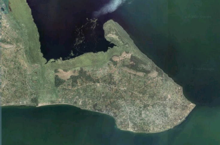
    • Vidéo :Here we are un Uganda, in the region of N'Kosy, with Didier Pillot. As we have no topographical map of this area, we are going to carry out our initial analysis using satellite images.

      • General description of the studied area and the method
      • First observations on satellite data
    • Exercise for yourself: Analysis of the peninsula. Using the satellite images, identify the different environments and proceed with an initial zoning of the peninsula.Then trace a route that will allow you to observe the field in the different types of environment.

      To view the study zone for the exercise on Google Maps, click on this image.   GE

      • Detailed observation of each part of the peninsula
      • Establish a transect
    • Explore the N'Kosy area with the picture tour.

      Advice: this visit uses the software Prezi®. If you are not familiar with this software, we recommend that, to begin with, you only use the arrows <= and => on your keyboard to browse through this presentation.

    • Vidéo : From an elevated point, Didier Pillot and his group of students compare their observations with those already made with Google Earth®.

      • Find our way in the field
      • Observe cultivated land
      • Observe land occupation
      • Observe the soils
      • What kind of tools do we need to observe the landscape
      • Second high point: the peninsula
      • Groups split up to cover the study area
    • Vidéo :The agrarian landscape is extremely rich and varied. Didier Pillot gives you some advice on the discriminating elements to be observed.

      • The key features of the landscape depend on the context
      • Frequent important elements of the landscape
    • Vidéo :Didier Pillot presents the advantages and disadvantages of carrying out field observations alone or in a group.

      • Everyone looks at the landscape in his own way
      • Individual or group observation
    • Vidéo :Didier Pillot presents the observation instructions given to the group.

      • Broad context: several groups studied the landscape
      • The groups looked for specific elements in the landscape
      • The groups' results
    • Vidéo :

      Didier Pillot presents the results for the student group 5: A representation of their transect, identifying the homogeneous agro-ecological zones.

      • Group 5 path
      • Description of the 3 types of zones found
      • Student results
    • Now let’s travel to Mali and more specifically to the cotton farming area of Sikasso. The researchers are having trouble answering the question: has cotton farming improved the farmers’ standard of living or not? This is the so-called “Sikasso” paradox.

    • Vidéo : Sébastien Bainville presents the Sikasso paradox.

    • Written exercise: Statistical analysis and the Sikasso paradox. Carefully read the attached study, one of the most developed analysis of the situation, and then answer the question:
      “Has cotton farming influenced the economic situation of farmers? To what extent, how and why?”

    • Vidéo : Sébastien Bainville paints an overall picture of the history and environment of Sikasso.

      • The main historical periods of the area
      • The main ecosystems of the area
    • Vidéo : Sébastien Bainville describes how farming activities were organised in Sikasso before cotton was introduced.

      • Cropping Systems
      • The social organisation of production
    • Exercise: Sikasso before cotton. Do you clearly understand the farming situation of the Sikasso area prior to the sixties? This exercise will help you to assess your knowledge.

    • Vidéo : Sébastien Bainville tells you about the golden era of cotton in Sikasso, from 1960 to 2000.

      • Introduction of cotton farming
      • 1960-1980 The extension of cotton farming
      • 1980-2000 The intensification of cotton farming
      • Agrarian re-organisation related to cotton farming
      • Subdivision of large families
    • Vidéo : Sébastien Bainville tells you about the cotton crisis in the 2000s and its impact to date.

      • The cotton crisis and its global impact
      • Impact of the crisis on the different types of families
      • Explanation of the Sikasso paradox
    • Bonus Exercise: Go back over the history of Sikasso. You must place the main changes brought to the farming systems in the correct historical period.

    • The Sikasso case illustrates that it is important to study the Agrarian History of a region to understand its organisation. But how do you go about this?

    • Vidéo : Elisabeth Rasse-Mercat reviews the Sikasso case and the working hypotheses and the presuppositions that must be kept in mind for the historical study.

    • Written exercise: the sources of information for the historical study. You are in charge of carrying out a historical study in an area that you are just getting to know:

      1. Which resources and which people will you call upon?
      2. Which source(s) of information will you begin with?

      • Resources not to begin with
      • What to do first
    • Exercise: the interview guide for a historical interview.
      You will first interview older farmers. Compose an interview guide:

      1. To answer the questions raised by the landscape analysis
      2. To clarify the history of the farms in the area and the factors or events that led to change

      To (re)view the interview guide preparation method, look at the lesson "Qualitative survey methods applied to natural resource management” (Module 2, lesson 4).

    • Vidéo :Sébastien Bainville introduces the concepts used to study the Sikasso paradox.

      • The system approach
      • Cropping System
      • Production System
      • Agrarian System
    • Exercise: Analyse an interview and extract the key information. Elisabeth Rasse-Mercat interviewed an older farmer in the Villeveyrac basin. Watch and analyse the interview to extract the information that will allow you to compose the region’s agrarian history.

      To review or carry out the landscape analysis of this area, click here

    • Exercise: Compare the information with another interview to reconstruct the history of the region. Elisabeth Rasse-Mercat held another interview in the same area. Watch and analyse it to extract the key information that you can then compare with the information collected from the previous interview.

    • Vidéo :Elisabeth Rasse-Mercat shows how, by adding some bibliographic data, the information collected from these two interviews allows you to reconstruct a large part of the Agrarian history of the Villeveyrac region.

      • The main historical periods of the Villeveyrac area
      • Pre-WW2
      • Post-War: mass wine production
      • 1970-2000: Wine crisis
      • Contemporary period
      • Farm diversity
    • Written exercise: Compose a historical timeline. From all of the previously gathered information, compose a chronological timeline that represents the Agrarian History of the Villeveyrac basin, with a focus on the appearances, disappearances and evolutions of:

      • Farming practices
      • Types of farms
    • We have formed an understanding of the landscape and looked at its history. We are now going to try to establish a famer typology according to their strategy.
    • Vidéo :What is a typology? Nicole Sibelet explains and illustrates this point through her own experience in the field in different locations across the world.

      • What is a type?
      • How many types for a typology?
    • Vidéo :Typologies cannot be composed according to recipes, but require reflection. Nicole Sibelet gives an example.

      • There is no "standard" typology
      • Typology: a typical case study
      • A few clarifications
      • Statistical tools and typology
    • Vidéo :Didier Pillot looks at the first results obtained to start forming a typology that represents the diversity of situations.

      • The sources of agricultural diversification
      • The strategies and decisions of those involved
      • The limited rationality of those involved
      • The qualitative approach and the reasoning behind the composition of the sample
      • The landscape and history for pre-typology
      • The reasoning behind the sample
      • Preparing the interviews of those involved
      • Creating an interview guide
    • Once all of the synthetic fact sheets have been informed, you can start composing the typology.

    • Vidéo :Didier Pillot presents the method and the results for the construction of the N'Kosy farmer typology.

      • First cases define the first categories
      • How to classify the marginal farms
      • Refining the types: typology is an iterative process
      • Typology process
      • Type 1: Preparing retirement farmers
      • A specific case
      • Type 2: Struggling for diversification farmers
      • Discriminating factors that come out of analysis
      • Type 3: Struggling for surviving farmers
      • Type 4: Extensive cattle breeders
      • Types 5 and 6: Businessmen farmers

    • Exercise: Classifying a farmer according to type. You previously composed a fact sheet for Emmanuel. Where would you classify him in the typology presented by Didier Pillot?

    • Reflection exercise (no solution): A questionable case. Watch the part of the interview, with this farmer, on farming practices. Then think about the following question: how should we treat this case in our study? (Should we ignore it? Develop it? Who can we question to find out more? etc.)

    • Bonus exercise: Classify the synthetic fact sheets provided according to Didier Pillot’s typology.

    • Vidéo :Why is it useful to understand the different types of farming in an area? Didier Pillot provides a few illustrations.

    • lectureTo read first:

    • LANDSCAPE AND ZONATION

      Controversy about "Zonation"


      Six experts involved in the development of this course debate the question of zoning. Each one illustrates his/her position and puts it into perspective using experiences on the field. 
      On the agenda:

      Part 1

      • Analysis of the landscape: essential or a time-consuming luxury?
      • Is it necessary to have the viewpoint of an informed expert or one with no preconceived ideas?
      • In which season should it be done?
      • What does a farmer's viewpoint of the environment bring to this question?
      • What is the interest of adding viewpoints from different disciplines, like sheets of tracing paper superimposed on a model?  
      • What should be the criteria for explaining and zoning a landscape?
      Part 2

      • Zoning according to biophysical data does not necessarily exemplify the diversity of ways to value the landscape; examples in Uganda and Cameroon!
      • A list of pertinent factors explaining the diversity is necessary to develop in each case!
      • The toolbox to carry this out must be well-stocked!
      • Farmers always have good reasons to do what they do, but the reason that they cite is not always the good one!
      • It is necessary to go into people's homes, but it is also necessary to know when to keep the distance.

    • AGRARIAN HISTORY

      Agrarian History

      Just as one cannot accept only a snapshot of the present in order to understand the diversity of strategies...
      Just as one strategy is not simply a project, but it is part of a dynamic, a continuum...
      Just as we make the assumption that the present is the result of History and that the future is built on the decisions made today...
      ...thus, we can affirm that a Historical study is not a time-consuming luxury reserved for researchers, but that it is essential for an astute approach to actors' strategies AND system dynamics 

      But what History/histories to question and how?
      That of institutions? That of agricultural policies? That of techniques? That of families? That of farms? The general History of states? And that of land tenure, soil, population, climate and the market?

      Based on who: the elderly, scholars, decision-makers, citizens?

      • Interview people individually or in groups?
      • How to handle uncertain memories, discourses about the "good old days", explanations made by knowledgeable people and those considered leaders? 
      • Do we know how to quantify historical dynamics?
      • Do we know how to evaluate a systems' resilience or a farmer's reactivity?
      • Can we map elderly people's memories, compare them to photographs, to perceptions?
      • Do we know how to confront discourse and figures?

    • TYPOLOGY

      Controversy about "Zonation"


      The "typology" is the brainchild (sic !) given in general as a major element to conclude/finalize a study.

      The debate about this topic among the authors of this course has obliged them to return to the fundamental questions that must be asked for every study:

      • Prepare the problem statement
      • What are the variables.
      • From who do we collect data, how should the data be analyzed, confirmed, completed?
      • The necessary simplification of complex systems: who/what is beyond, who/what is within? Where are the boundaries of the model?
      • Who should be involved in the study? What disciplines should be involved?

      How to make decisions about the topic: desire to understand everything without being able to finish versus oversimplifying and making false conclusions  
      Finding a truce: and finally, a peace pact is signed in the war between Qualitative and Quantitative: each has its rightful place at the right time!

    • Altogether this is a dynamic way to recall or to put into perspective the lessons of the course “Qualitative survey methods applied to natural resource management” when applying them to diversity analysis...


    • Give us your opinion on this online training: The file must be downloaded, then completed and finally uploaded here below.